views
Finding Distance Using the Bar Scale
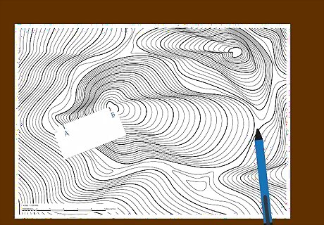
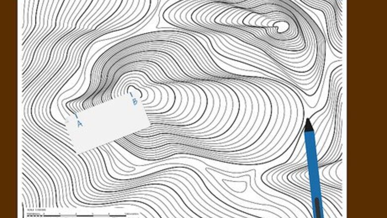
Lay a piece of paper down on the map and mark it. Place a straight edge of a piece of paper onto your map. Line up the edge with both the first (“point A”) and second (“point B”) points you want to measure the distance between, then make a tick mark on the paper where each point is. Make sure your piece of paper is long enough to make your 2 tick marks. Note that this method works better for shorter line distances. Hold the edge of the paper still on the map and mark as accurately as possible where the paper lines up to your 2 points.
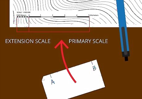
Hold your measurement up to the bar scale. Locate the bar scale on your topographic map, which is typically found in the lower left. Place your piece of paper with the 2 tick marks against the bar scale to begin to read the distance indicated. Note first the ratio that's represented by the bar scale. This indicates that 1 unit of measurement on the map equals a certain number of units on the ground. For instance, a common topo map might have a 1:100,000 scale, where 1 centimeter equals 1 kilometer. The bar scale may also contain a primary scale, which shows whole units increasing from 0, left to right. There's also an extension scale, which shows fractions of a unit increasing from 0, right to left. Use this method if you have a short distance between your tick marks that easily fits within the given bar scale.
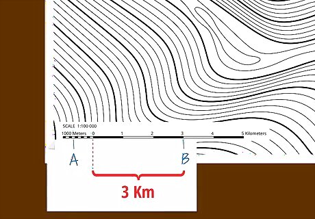
Interpret the largest portion of distance from the primary scale. Align the tick mark on the right side of your paper edge with a whole number in the primary scale of the bar scale. The left tick mark should fall somewhere within the extension scale. Where you line up the right tick mark on the primary scale depends on what it takes to fit the left tick mark onto the extension scale. Keep the right tick mark on a whole number. The whole number the right tick mark is on indicates that your ground distance is at least X-many meters/kilometers/miles as the scale indicates for that number. You'll find the rest of the distance more precisely with the extension scale.
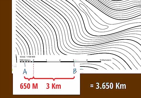
Read the extension scale for the smaller numbers. Determine the rest of your measurement in smaller increments using the extension scale of the bar scale. Where your tick mark lands will indicate what tenth of a whole unit will be added to your total measurement. The segments on the extension scale are typically small rectangles, alternately shaded and unshaded for easy reading. You can guesstimate at even smaller increments by visually dividing each rectangle into 10ths and seeing where the tick mark falls within the rectangle. For example, on a bar scale that shows 1,000 meters for every inch: If you align the right tick mark on the 3 mark, you have at least 3,000 meters in your measurement. If the left tick mark falls on the rectangle in the extension scale that indicates 900 meters, you'll have an additional 900 meters in your measurement. Your total measurement would then be 3,900 meters.
Finding Distance Using the Representative Fraction
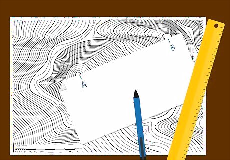
Mark the edge of a piece of paper. Put down the straight edge of a piece of paper onto your map between the two distances you want to measure. Make a tick mark on the paper’s edge to indicate your “point A” and one to indicate your “point B.” Hold the piece of paper still and evenly against your two points in order to make the most accurate tick marks. If you want to, you can use a ruler or tape measure straight on the map, and note down the measurement to the smallest fraction of a unit possible.
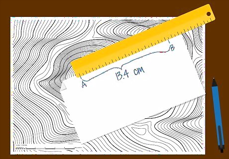
Measure the distance with a ruler. Place a ruler or measuring tape up against your piece of paper with the two tick marks and note the distance from one to the other. Use this method when your distance is too large for the bar scale given on the map, or you want to find a precise measurement using numbers. If measuring with centimeters, find the distance to the nearest millimeter. If using inches, find the distance to the nearest eighth of an inch. Note the scale given at the bottom of the map. It should show a ratio and a bar scale in both centimeters and inches. If one equates to a whole number, like 1 centimeter = 1 mile, you might choose that unit for easiest measuring.
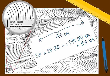
Calculate the ground distance from the measurement. Use the representative fraction, or ratio, of the map to find the ground distance based on your measurement on the map. Multiply your distance by the scale number. For example, for a map with a scale of 1:10,000: If you measured 10 centimeters from your Point A to Point B tick marks, you would multiply 10 by 10,000 to get 100,000 centimeters, the true ground distance from Point A to Point B. You can then convert your number to a more relevant distance. 100,000 centimeters equals 1 kilometer, for example, which is about 0.62 miles.
Taking Further Measurements
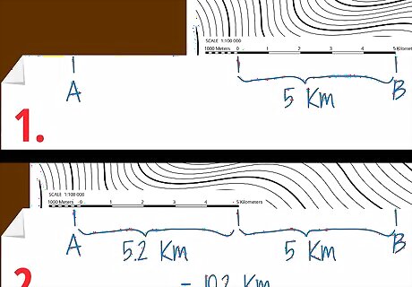
Measure a distance that is too long for a bar scale. Determine if the distance between your two tick marks is too long to match up to the bar scale. In this case, you can either take several measurements with the bar scale to get the total, or use a ruler or tape measure instead. To use the bar scale for a longer measurement, place the right tick mark on the farthest number on the primary scale. Make another mark on your paper where the extension scale ends on the left, and note this distance. Use your new mark as the right tick mark and measure using the bar scale as normal. Add this to your previous number to get the total distance. If you are measuring the distance between your tick marks or 2 points on a map using a ruler that is not long enough, try a tape measure for more length.
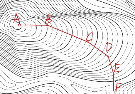
Measure a curved line with straight line segments. Determine if the route you want to measure has multiple points or takes the shape of a curve rather than a straight line. In this case, take multiple straight line measurements and add them together. Use a piece of paper to mark the distance on the map. Measure several straight lines along the curved routes and add them together. For the greatest accuracy, measure a greater number of smaller straight lines along a curved route.
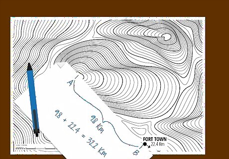
Calculate distance to a point off the map. Determine if your map indicates the distance from the edge of the map to another popular destination not shown—like a town, highway or junction. Add this distance to a straight line measurement from your other point to the edge of the map. Use a piece of paper or a ruler to measure the distance between point A to the edge of the map. Add the distance the marginal information of the map gives to the desired town or highway to get the total distance. Be sure that your units of measurement are the same before you add the two distances.


Comments
0 comment